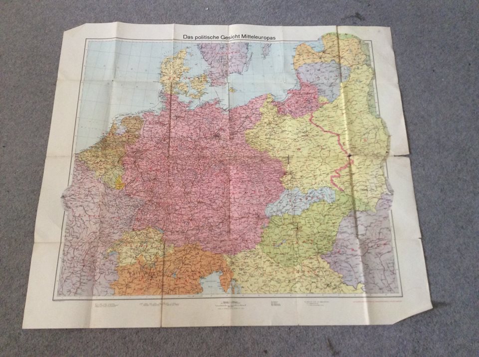
Partly due to despair at my unwillingness to decorate my flat in any way whatsoever, and partly because she knows I like this kind of thing, a friend of mine sent me this antique map of central Europe as a gift. She obtained it in an antiquarian map shop in Krakow, Poland.
First, obvious observation. This is a map from Nazi Germany. In the margin, it is identified as being the product of a mapmaker in Leipzig, but there is no date given.
Secondly, when I see a historical map, I like to play the game of figuring out the dates of the map by looking at the border, and using my historical knowledge of political geography to narrow the date down.
Figuring out the year of this map is easy. This map is from 1939. In most instances, getting the year is all you want to do. However, 1939 was a somewhat problematic year.
Klaipeda and the area around it is shown as part of Germany, not Lithuania. Also, Czechoslovakia has ceased to exist, Bohemia and Moravia has been annexed by the Reich, Slovakia is a supposedly independent country, and Carpathian Ruthenia has been invaded and annexed by Hungary. All these events occurred in March 1939, so the map was clearly designed after March 1939.
It’s looking at Poland that things get interesting. Firstly, Danzig is not shown as a free city, but is shown as part of the Reich. Danzig was invaded by Germany on 1 September 1939, proclaimed part of Germany on 2 September, and formally annexed under German law on 8 October. Danzig had, however, been under the control of the local Nazi party since 1933, and would have joined Germany instantly if it had been allowed to under international law. Is it possible that some German maps showed Danzig as part of Germany prior to September 1939? Possible, but I suspect probably not.
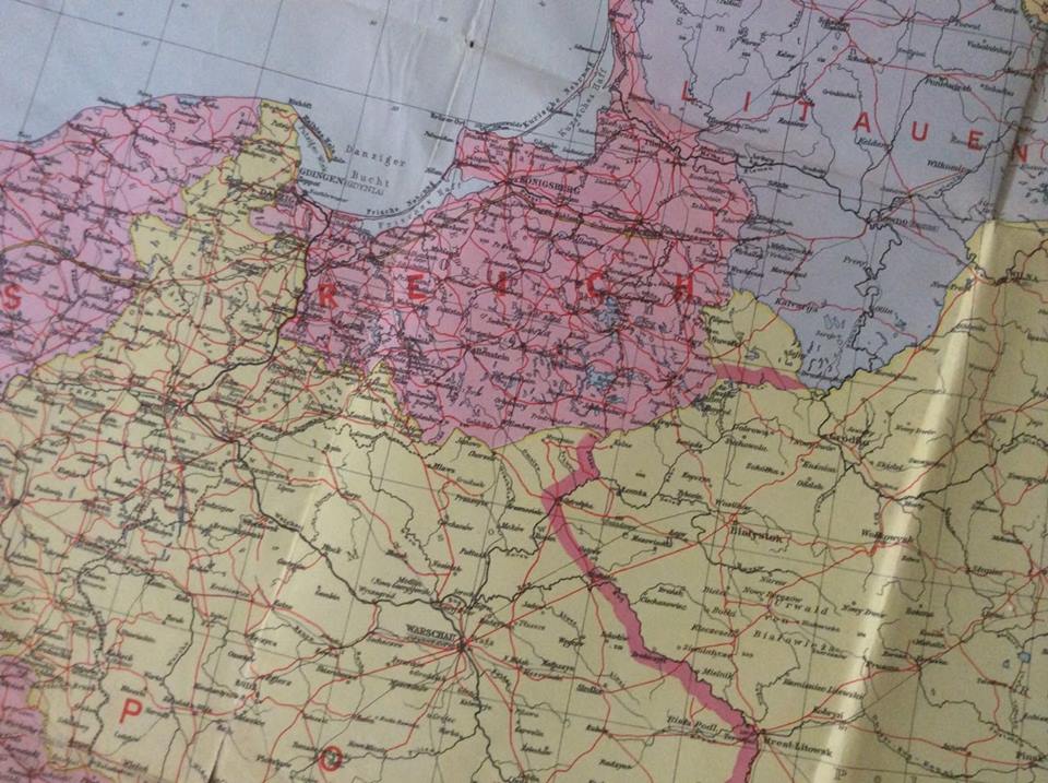
By far the most fascinating thing in this map is the red line through Poland, however. Poland is clearly identified as “Polen”, but the Molotov-Rippentrop line – it the limits of German occupation after the invasion of Germany in September 1939 – has been drawn through it. Therefore the map must have been printed no earlier than September 1939. This has clearly been printed at the same time as the rest of the map – it is not something someone added with a pen later, or anything like that.
What I suppose is possible is that the mapmaker had a map prepared reflecting recent border changes immediately prior to the German invasion of Poland in September 1939. When the invasion occurred, the map was quickly modified to show Danzig as German and the zones of German and Soviet occupation before being printed and sold.
And yet, this map does not reflect the view of the world that the Nazis wanted to present. Upon invading Poland, they declared that Poland as a country did not exist. On that same date of October 8, Germany formally annexed the northern and western sections of their Polish conquests (including the Suwalki triangle, clearly shown on this map), and declared the South-East to be the “General-government”, essentially a German colony (but not a “Germany colony in Poland”, as Poland did not exist). This map is therefore curious, as it essentially shows Poland (clearly identified as Poland) under German (and Soviet) occupation.
I cannot imagine maps like this being printed in Germany long after the annexation decree of October 1939. In the Nazi view, there was no occupied Poland the way there was later an occupied France. There was simply German territory that unfortunately happened to have Poles, other Slavs, and Jews living in it. It’s easy to imagine foreign maps from later showing the German and Soviet occupation of Poland like this, but German ones, not so much. So my conclusion is that this map was printed very soon indeed after the German invasion of Poland in September 1939.
Plus of course this map ended up in an antiquarian map shop in Krakow in Poland, which between 1939 and 1945 was in that aforementioned “General Government”. One has no idea how and when it got there, but I suspect that “during the occupation” is the most likely answer.
Thoughts anyone?


Michael,
Something I do with old large documents and maps is scan them as tiles and then use my camera software to assemble the tiles into a single image. It creates an exquisitely detailed reproduction that can be easily examined right down to the fiber size if scanned at that resolution. Then I make lesser sized copies of the recombined image that are easier to handle for some uses.
While not as much work as it sounds, it is still an effort and some time. This map is rare enough and historically significant enough that it might be worth the effort. Its value for future reference is significant. History is (re)written by the winners, this is probably the least skewed information available of that point in time.
Midwesterner -> seconded !
I’d like to print it out A1 sized and put on the study wall….
It sounds like you’ve answered your own question; the map was printed after the invasion in September but before the formal annexation of the Polish territories in October. The area may (per Nazi propaganda) have not been a country but it would have needed some sort of name to label it, and in the absence of a new name for the land in question it was “Polen.”
My thought is that you made a typo in the second-last paragraph, “October 1940”.
Perhaps it was printed after the partition was announced, but before the declaration of annexation? (My first thought was that the mapmaker might not be up on the political status of the countries in question, but if any profession short of politician would be, mapmakers making maps entitled “The Politics of Central Europe” would be it).
Yes, I did. I meant October 1939. Now fixed.
What were the Germans doing with a map in red? Wasn’t that reserved for the British Empire (before the commies used the colour for themselves?)?
They should be careful, or we’ll send a gunboat!
I think a map of Central Europe as it exists now is better – for once I think the modern situation is better than the old (at least this period) one. Although it is unfortunate that eastern Poland is under the rule of Minsk. As for East Prussia – well city of Kant and all that, but it is Russian now (after the crimes of the Germans in both World Wars it is hard to see how it could be otherwise, and the “Prussians” were originally a Slav tribe invaded by the Teutonic Knights).
Maps of the old Holy Roman Empire are interesting (incredibly colourful and complicated).
Paul, Minsk can’t even rule itself. It is a shit-hole supported by chums in Moscow. It is the last vestige of the Soviet empire. Poland is EU and NATO. Give me strength! I have been to Poland several times (I have rellies) and that is just bollocks Paul. What is fascinating is the map of Poland over the centuries expanding and contracting. You can can tell you’re in the middle of Europe when your borders go everywhere. Quit shocking to a Brit like me where our borders are pretty much defined by the sea.
Minsk is weird. I was there last month. “Shithole” is not actually fair. It’s not exactly that (and I have been to some shitholes). More to write about, I suppose.
Well Nick if you say that what was Eastern Poland is not really Poland – fair enough (I am no expert on the area).
On “”White Russia” – yes a puppet state of Putin (and worse).
The eastern bits of pre WWII Poland were more ethnically mixed than the western bits. Countries that were looked upon favourably by the victorious powers at the end of WWI tended to get more expansive borders than those that were not. A consequence of this was that those countries also got more ethnically mixed populations. Poland was looked on favourably, so borders were drawn in which most Poles were in Poland, but also so were a lot of Belarusians and Ukrainians. Hungary was not looked on favourably, which meant that Hungary was more ethnically homogeneous, but there were a lot of Hungarians outside Hungary’s borders. The cities of eastern Poland contained Belarusians, Ukrainians, and (in the case of Vilnius) Lithuanians, which was part of Stalin’s justification for annexing them to the USSR, but they also contained a majority of Poles (except perhaps in the case of Vilnius) and Stalin’s pact with Hitler to invade and his annexation of the territory in question after WWII was a huge offence against the Polish nation and Poland quite rightly should have been aggrieved. They were given other, formerly German, territory to compensate, and it was much harder for German to complain because, well, they started the war and treated everyone abominably, but Poland still lost territory that was legitimately part of its country through unspeakable aggression on the part of its neighbours . Getting Breslau/Wroclaw in return for Lviv – no, that does not make up for the loss of Liviv.
Of course, Lviv was as much a Jewish city as a Polish Catholic city and the Jews fared much, much worse. This doesn’t take away the illegitimacy of Poland’s loss of Lviv, but one mentions it.
The map has to have been produced after the end of the 1939 Polish campaign, as I don’t think the delineation of the occupation zones was published until then.
The Nazi pretense was that Poland had attacked Germany and was acting in self-defense (and to “liberate” the Germans of Danzig). So the terms of the Molotov-Ribbentrop deal were not published as such; instead the border was disclosed as a more ad-hoc arrangement. (I think.)
However, as Michael noted, it can’t have been very long after, since Germany annexed Polish territory, which isn’t shown. Also the USSR annexed Polish territory, and that isn’t shown either.
I would set the date as early October 1939.
Nick,
The U.S. Republicans were using Red long before the Commos, and
What seems to have been forgotten that the Germany of 1914 is different to the Germany of today and Prussia was much closer to Russia than the rest of Germany and today what used to be Prussia is now part of Russia, so in 1919 when it was feared the Russians would be there in 20 years wasn’t far out – GDR.
Post WW2 Poland, not yet fully Bolshevized in politics, was moved west. The new border cut through a farm, and the local joint committee implementing the border sent a People’s Delegation to ‘consult’ with the farmer as to which side of the line he would like the farm to be on. ‘Poland’ he replied.
‘Are you an Anti-Soviet?’ asked a Commissar.
‘No, I love Stalin like my father, but I never could stand those Russian winters’.
Danzig was not part of Poland. It was a Free City State from 1920 to 1939 under the control of the League of Nations. Poland was in a customs union with it and was allowed access to the port. The fact that the Nazi’s were in power in Danzig from 1935 would lead propagandists to show Danzig as part of Germany even though it wasn’t.
Germany invaded Poland on Sept 1, not just Danzig and they quickly absorbed the historic (ie. pre 1918 frontiers of Germany) that formed part of Poland. This area already contained many Germans (albeit perhaps not a majority). By 1939 many historic German areas had be reunited with the Reich. They include Sudetenland, Memel and The Czech part of Czechoslovakia. The latter having a minority of Germans. It’s unlikely that a German map maker would be unaware of these facts. Consequently I have trouble understanding why the map doesn’t show the 1914 border areas in pink.
If that was all then I would date the map to earlier in 1939 because at that point, only the Danzig corridor was being publicly demanded, which fits with only Danzig being coloured pink. However that explains everything except the Molotov Ribbentrop line.
Is it possible that the map was created as part of the Molotov Ribbentrop negotiations? ie this map is what they signed to.
The American Republicans were using red long before the Communists…..
Well I thought that it was a television network thing – from only a few decades ago.
However, even if (for example) President Grant was using a Red Flag to indicate Republicans back in his elections of 1868 and 1872 it still post dates the Communists (who was using the Red Flag long before that).
By the way the Republicans never did wave a Red Flag (as far as I know) – it was the “bloody shirt”, a shirt of the candidate (whoever they might be) with his blood stains on it (from wounds in the Civil War).
Most Republican candidates or office having served in that war – and on the side of the United States.
Remember in contested areas (such as East Tennessee – the First and Second Districts of Tennessee being Republican) the Republican candidate had to have something with which to counter the “class” and “race” based politics of the Democrats (and the Dems were doing the anti rich tap dance in some States even in the 1890s – although the form of race based politics they used back then was anti black rather than pro black).
What Republicans used was National Union – the Stars and Stripes (and, sometimes, the Bloody Shirt).
However, (contrary to what a lot of people think now) it was a national union with a very limited Federal government.
The Federal government could be used against statism (as well as for statism).
Governor (later Senator) Bilbo of Miss… was denouncing Republicans as tools of the rich (puppets of big business) from the 1890s to the 1940s.
The Republicans (so such Populist types warned) would use the power of the Federal government to prevent the States following “Progressive” polices (such as ripping up private contracts – as Mr Martin Woolf of the Financial Times supports Argentina doing, he denounced the recent Supreme Court judgement in favour of the creditors in terms of which Governor Bilbo would have been proud) – hard to believe now, but at one time the Federal courts were seen that way. There were Progressive Republicans (many of them) – but the “pro business” Republicans were feared.
Ditto Governor Bilbo claimed that the evil Republicans would prevent the lynching of “n…..” – Governor Bilbo pointed at the pressure in Congress to stop such things as the noble Knights of the Invisible Empire (the KKK) riding out to burn, mutilate and kill.
After all the “extremists” and “religious fanatics” who had created such things as the National Rifle Association (the enemy of the noble KKK) even wanted blacks to be allowed to own firearms!
Where is the fun in killing people who can defend themselves?
The once famous “Middletown” (really Munsie Indiana) sociological studies (from the 1920s and 1930s) cover some of this.
The refusal of American workers to think in “class” terms (must to the distress of the sociologists). Voting for their employers (seeing the interests of “rich” and “poor” as the same – the Republican “Elephant” rather than lots of different interests, the running donkeys, see the famous 19th century cartoon).
And incidents such as when the KKK (as part of its northern expansion) came to “Middletown” – only to be driven out by…. the Rotarians.
“Babbitt” with teeth.
Although (in those days) businessmen would have served in the army during World War One.
Paul Marks,
Jeez I was just being flippant but the First Transnational Unpleasantness blew the claim of the existence of the International Proletariat out of the water who worked the factories to make the munitions and fixed bayonets and went over the top to kill their comrades in the international proletariat. The flag of the National Socialists is predominantly red.
But anyway, thanks for the feedback, America is a place of contradictions, God bless ’em, besides ‘What’s this shooting back shit?’
I am sorry Regional (I apologise) – I really did not mean to attack you (I did not think I was).
I am told that I can be aggressive at times – without even knowing it.
Too long in security – and dealing with car boot sale lines.
“Please turn left”.
Burble, burble.
“There is a massive line behind your car please turn left”.
Burble, burble.
“MOVE!”.
Then the next car of thousands.
Paul Marks,
I did not take offence at your remarks and apologise if it appears that way, but onward and upward and the big question is when’s the International Ponzi Scheme going to come unstuck?
I see that Italy then was slightly larger than it is now.
That is the big question Regional.
And I just do not know.
I am astonished that it is still there – I would have expected it to fall apart before now.
Of course a lot of other people are also astonished – and some of them are going back into the markets.
“There are no laws of reality – we can just print ourselves rich”.
I think this is a mistake.
But then I thought the bubble would blow last year…..